Hurricanes, Typhoons, Tropical Cyclones
Formation and Saffir/Simpson Hurricane Scale
Hurricanes, Typhoons and Tropical Cyclones are one of the same and the name indicates where they occur. Hurricanes are found in the Atlantic and north eastern Pacific, Typhoons in the north western Pacific Ocean and Cyclones in the south pacific or Indian Ocean.
A hurricane is a low pressure system which has organised thunderstorms but doesn’t have a frontal weather system. There are several sub categories defined as follows. If the sustained surface wind speed is less than 39 mph this is a tropical depression. If the sustained surface speed is greater than 39 mph it is a tropical storm. Once the speed reaches 74mph it is classed as a hurricane.
The strength of the hurricane is measured by the Saffir-Simpson Hurricane Wind Scale and has a rating from one to five.
The scale to the below shows the wind speeds, category, Storm surge and potential damage.
| Saffir/Simson Hurricane Scale | |||
|---|---|---|---|
| Catagory | Wind Speed Range | Storm Surge | Potential Damage |
| 1 | 74 - 95 mph, 119 - 153 km/hr | 4 - 5 ft, 1 - 2 m | Minimal |
| 2 | 96 - 110 mph, 154 - 177 km/hr | 6 - 8 ft, 2 - 3 m | Moderate |
| 3 | 111 - 130 mph, 178 - 209 km/hr | 9 - 12 ft, 3 - 4 m | Extensive |
| 4 | 131 - 155 mph, 21- - 249 km/hr | 13 - 18 ft, 4 - 5 m | Extreme |
| 5 | > 155 mph, >249 km/hr | >18ft, > 5M | Catastrophic |
Hurricanes form in the Atlantic Basin, Caribbean Sea Gulf of Mexico and the eastern Pacific Ocean. They may also form in the central North Pacific Ocean. There’s a six year rotating list of names used to identity the storms. In the Atlantic they are called Hurricanes, In the Pacific they are called Typhoons while in the Indian ocean they are referred to Cyclones
The Hurricane season starts from June the 1st and ends of November the 30th although Hurricanes have occurred outside these times.
There isn’t a season for Typhoons as these can form in the North Western Pacific at any time.
The Tropical Cyclone in the Indian ocean runs from April to December. This is in fact two peaks as there is very little activity between July and August.
Hurricanes form over the sea when warm wet air rises forming Thunderstorms and this also creates a low pressure area near the sea surface
As more warm air rises this causes the pressure to decrease at high latitudes. The warm air is under high pressure than the cold air so moves towards the space occupied by the colder low pressure air. Effectively the Low pressure sucks warm air in from the surroundings.
Air rotates rotates round the centre of the low pressure at increasing speeds as air is ejected from the top of the storm and the pressure decreases in the eye of the storm.
Air rotates rotates round the centre of the low pressure at increasing speeds as air is ejected from the top of the storm and the pressure decreases in the eye of the storm.
In the centre of the hurricane is the eye. The eye is often clear due to cold descending. Below from the BBC is a cross section of a Hurricane.
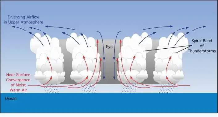
Inside a Hurricane there will be heavy rain strong winds, Thunderstorms, and Tornado’s. Intense Hurricanes often go through what is called an eye wall replacement. This tends to be in Hurricanes of category 3 and above. The eye wall contracts or if it’s already sufficiently small, some of the outer rain bands may strengthen and organize into a ring of thunderstorms forming an outer eye wall. This slowly moves inward and robs the inner eye wall of its needed moisture and angular momentum. Since the strongest winds are in a cyclone's eye wall, the tropical cyclone usually weakens during this phase, as the inner wall is "choked" by the outer wall. Eventually the outer eye wall replaces the inner one completely, and the storm may re-intensify. A hurricane may fail in the process or try several times before it successfully completes. Eye wall replacement may occur several times during a lifetime of very strong Hurricane.
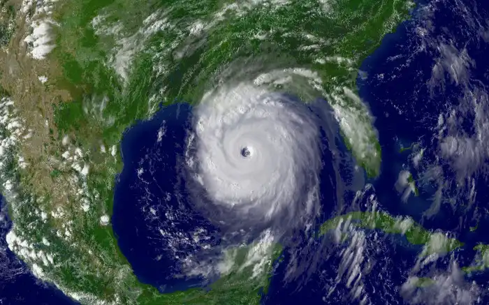
The picture below is of hurricane Katrina from nasa. Note the well defined clear eye wall.
Typical Life Time of a Hurricane, Typhoon, Cyclones
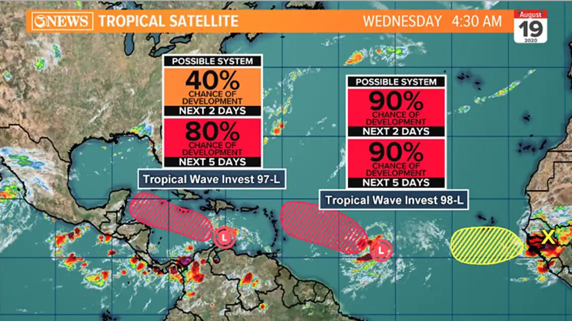
The process for the formation is the same so we will take the life span of a Hurricane as an example. This starts with a Tropical disturbance or wave which is a organised area of Thunderstorms. These are given a name of Invest and then a number. The possibility of Hurricane formation is given. In the Atlantic they form of the African west coast and have their origin believe or not in the Sahara desert. These waves move west across the Atlantic. The picture below shows a typical formation and labelling of such waves
As they move across the Atlantic Thunderstorms develop into a closed area of low pressure.
If Conditions are favourable and strengthening continues it will become a Tropical Storm. The storm will be given a name and if there's any further strengthening it will become a hurricane. The name comes from a list released each year starting from A.
The hurricane will weaken once it reaches unfavourable conditions.When the wind speed drops below 74mph it then be named a tropical storm. The next stage of weakening is when the wind falls below 39 mph at which point it will be named a tropical depression.
When Hurricanes move over land due to friction will rapidly decline in strength. However if the land mass is small enough and they move back over warm water they may regain strengthen. If weakening is enough they'll be reclassified anf then classified back to a hurricane if the system regains it's strength if the water it's over is warm enough and atmospheric conditions are still suitable.
When Hurricanes move over cold water they will again lose strength as they have lost one of main sources of energy. Again if they move back over warm water they may regain strength.
Dry air will also weaken Hurricanes and if it is persistent the Hurricane dissipate.
Shear also will destroy hurricanes and any hurricanes entering an area of high level of Shear they will quickly decline in strength.
Hurricanes at the present time don't happen in the UK. However it's also possible if the climate warms enough this may change and like with extreme heat we are not geared up for such a thing happening. Although we may experience Hurricane gusts or sustained winds at hurricane force they will not be hurricanes due to having a full system of weather fronts.We often see the end of hurricanes which have been absorbed into another low system as they reach more northern waters. These will bring warm temperatures heavy rain and strong winds.