Thunderstorms and Lightning
Thunderstorms are one of the most interesting aspects of weather. They spawn the some of the most dangerous elements of our weather. These being Hail, Tornado’s, Flash floods, Lightning and Hurricanes
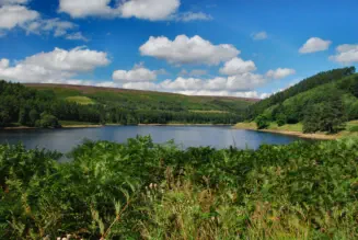
It’s hard to belief that Thunderstorms start the formation from Cumulus clouds. The picture on the left shows Cumulus clouds over Ladybower. Of course not all Cumulus clouds develop into Thunderstorms as several factors are needed to allow the continued building of the cumulus clouds. For the Storm to form there needs to be unstable air and heat or some type of forcing mechanism. I’ll deal with the basics first. First of all as the Sun warms the earth surface heating the air around it. As the air rises due to it being lighter than cool air this forms what is known as a up draft. If there’s enough moisture a cloud called a Cumulus will form. If the heating is strong enough the cloud will continue to form and grow larger.
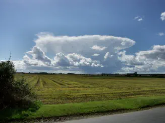
Eventually the Cumulus gets large enough enough water condenses out to form rain and raindrops fall as the rising air can’t keep them aloft. Cool air now enters the cloud and starts to descend creating an down draft making it rain.Once the cloud has reached maturity as it now known as a Cumulonimbus a Thundercloud. The picture on the left shows a Thundercloud. Note also other Cumulus cloud in the picture which haven’t grown due to lack of warm air rising.
Lightning starts to occur as Hail created in the higher part of cloud collide with other crystals as they rise and fall. The lower part of the cloud becomes negatively charged while the upper becomes positively charged.
The lightning heats the air causing it to expand which you hear as Thunder. The storm will continue to develop until the downdraught becomes to strong preventing formation of rain droplets and the storm will dissipated from the bottom to the top.
The wedge shape you see in the photo to the left is due to the warm air reaching a level in the atmosphere where it can’t go any higher so spreads outwards creating a cirrus anvil.
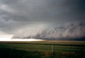
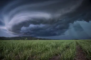
Another feature associated with Thunderstorms is a gust front. See the picture just above. This forms as cooled air from the Thunderstorm descends due to either drier air entering the cloud forcing the rain to evaporate and the resultant cooling allows the air to descend and or the falling rain causes a drag on the air forcing it downwards. The net result is a sudden increase and possible change in wind direction and a line of threatening cloud as can be seen from the picture on the right.
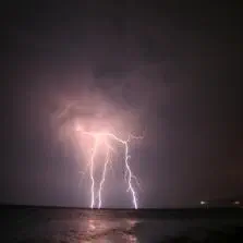
There are several types of lightning associated with Thunderstorms. Sheet lightning which is where lightning, is reflected in the cloud or seen from a distance lightning the horizon up. Forked lightning which travels from the ground to the cloud forming several forks as least line of resistance is found. A crawler this is like forked lightning but isn’t travels across the cloud or across clouds instead. The very rare Ball lightning the mechanism which are not properly understood and are very rare. The most dangerous lightning is a positive cloud to ground strike although rare this one is the one that causes the most damage. Other forms of lightning are Rocket Lightning, despite it's name this little understood stroke is where the propagation of the lightning stroke is slow enough to been seen by the eye. Pearl-necklace lightning is another rare from of lightning, also called 'Chain Lightning and Beaded lightning'. Pearl-necklace is where variations of brightness along the discharge path give the appearance similar to pearls on a string. Ribbon lightning is a ordinary cloud to ground strike which appears to be spread horizontally into a ribbon of parallel luminous streaks when a strong breeze is present at right angles to the viewers eye site. Streak lightning is a discharge which has a clear main channel which maybe tortous and branching. Streak lightning may be cloud to ground or from cloud to air. Sprites are upper level lightning which occur above the Thundercloud. It is believed they are caused by the positive lightning. Blue Jets project from the top of the Thunderstorm and don’t seem to be triggered by Positive lightning. The mechanism how they formed isn’t fully understood as of yet but they seem to be associated with intense hail storms. Sprites and Jets were first observed by airline pilots and later observed from the space station and the shuttles.
Super cells , see picture below left, are the big daddy of Thunderstorms. Very are very rare in this country but very common in places like the states. The are storms and not always thunderstorms either, that form up drafts that rotate due the shear in the environment when the storm begins to build. The nature of storm often produce damaging winds, large Hail, Heavy rain, and Tornado’s. The nature of the rotating updraft allows the Super cell to overcome the self limiting mechanism that limit the life of a standard storm. Super cells can also self maintain themselves overcoming environments that wouldn’t normally allow development of storms. Cells of this type may identified on the radar by the hook shape at the rear side of the Storm.
Another type of Thunderstorm is the high level storm which forms at high altitude approximately 2400m or higher. The main notable feature of these storms are the lack of rain as this tends to evaporate before it reaches the ground and the spectacular lightning which is easier too see due to the lack of rain.
A further term you may here is MCS or (Mesoscale Convective System) This is where a collection of Storms act as a system. A variation of this is MCV (Mesoscale Convective Vortex) This where a low pressure within an MCS pulls the winds into a circulating pattern. Where these move into tropical waters such as the Gulf of Mexico or of the coast west Africa these may eventually lead to tropical storms or Hurricanes.
I mentioned earlier there are several aids and factors to the formation of Thunderstorms. Most of all you need Cape (Convective available potential energy). This is the amount of energy a parcel of air would have if lifted a certain distance vertically in the atmosphere. This is the positive buoyancy of air and a indication of atmospheric instability. This is measured in J/kg. The higher the values the more potential for storms.
Aids and factors in the formation of Thunderstorms
mentioned earlier there are several aids and factors to the formation of Thunderstorms. Most of all you need Cape (Convective available potential energy). This is the amount of energy a parcel of air would have if lifted a certain distance vertically in the atmosphere. This is the positive buoyancy of air and a indication of atmospheric instability. This is measured in J/kg. The higher the values the more potential for storms.
Capping inversion or CAP. This is an elevated inversion layer that caps a convective boundary layer. Where this is present Storms won’t form until until temperatures rise higher enough to break through this layer. An observer can at times see this quite easily as clouds build only to spread out at a certain height. Only when the updraughts get strong enough will this layer get broken.
Li or lifted Index is rising parcel of air temperature when reaches the 500 millibars level subtracted from the actual temperature of the environment at that level. IF the Lifted Index is a large negative number it means the parcel of air is much warmer than the surrounding air and will continue to rise. This is a good guide of the atmosphere ability to produce severe storms.
Storms may form along weather fronts normally cold fronts although it can happen with other types of front. This where air is forced up by cooler air undercutting the main air mass thus providing the lifting mechanism needed to produce storms.